The route is amazing, it has always been a dream to do the trip with a little more time, and of course, a mountain bike.
In late March, Adam shot me a message seemingly out of the blue, asking if I wanted to drive a new mini-van from Seattle back up to AK and go mountain biking in the spring?
The timing could not have been better. A planned April ski-week was looking like it was going to get busted by a major heat wave, and I couldn’t do both trips in such a short span – Adam’s trip turned out to be the silver lining of the bagged skiing.
We had one week to pull the trip off, and we opted to go May 7-15 for scheduling reasons. This could be a bit early for such a trip most years, but low snow and a record hot spring across most the route meant basically all the riding we planned to do would be in.
Along the way we rode Bellingham, Whistler, Pemberton, Williams Lake, Burns Lake, Smithers, and Whitehorse. We discussed putting together a list of positives of each area we visited. So for the short version of the trip, here it goes:
Whistler: Common, this is no fair to anyone else on the
list. Everywhere should strive to be like Whistler. Anyway, what impressed me
most, was the incredibly defined evolution of riding. The green trails would be
great if you’ve never ridden a bike off pavement, the blue trails have more
furniture and features to learn on, but they are a reasonable progression for
someone with more than the basic skills and fitness, with occasional options to
hit side features that are a bit more challenging, and the black trails will
work over experienced riders and make them ripped and skilled.
Pemberton: My favorite trails along the trip, Pemberton
trails are about a half notch harder than Whistler. Don’t go here unless you’re
strong, know how to handle a bike, and don’t mind second guessing your skill
level. It’s been a long time since I’ve ridden something rated blue that made
me work hard, and I really think their blue trails meet the criteria for
“trail” description. No XC here, but plenty of hard riding! If I could only
ride one trail system for the rest of my life, Pemby would be a top pick.
Williams Lake: Lots of trails and an easy to navigate trail system. Williams Lake has done a lot to develop their systems, and despite not having a ton of different terrain to work with, they have made the most of it.
Burns Lake: Burns gets the best package deal, hands down.
They have a free, clean, basic campsite – maintained by the local bike trails
assoc – at the dang trail head, they have riding for every skill level – and it’s
used by every skill level too with people way outside the typical cyclist stereotype
making appearances, they are in the middle of absolutely nowhere, their trails
have great flow and are marvelously built with a lot of dirt work and furniture
to handle sometimes less than ideal hydrology, and they were hands down the
easiest trail system to navigate. They have new trails in the works, and I look
forward to visiting again!
Smithers: I got mixed reviews on Smithers before I went, and
was told there was no riding there for an XC/trail rat.
Dead. Wrong. Smithers has world class, rugged backcountry singletrack, and I desperately want to go back. Our only problem, we were there too early in the season and our hoped for routes were still snowed in up high. At least we got a taste.
Whitehorse: Whitehorse has tons of riding and great weather,
plus, their trail networks are a short pedal from the loads of cheap and free camping
in the area.
OK, so that was the short.
The longer version: we landed in Seattle on a sunny Saturday and the car salesman picked Adam and I up at the airport in the pimp’n new Sienna mini-van and drove us north to the dealership through heinous Seattle traffic. We had planned to ride in Seattle, but quickly decided we had already seen enough taillights, and built our bikes up in a back corner of the lot and headed north. A few hours and more traffic later, we were getting an earful of advice from some friendly riders at the trailhead of the Galbraith system on what to ride. They were supremely stoked on their trails, and pleased we’d ditched Seattle. So were we! The trails were really narrow, and surrounded by tall, thick-trunked conifers. We easily stitched together 2 hours or so of blue trails, briefly dabbling on some black trails, without too much map consulting. I won’t say these trails were my favorite of the trip, sometimes they were so ridiculously tight and narrow and I felt like we were poaching hiking tracks, but I’d definitely like to re-visit. Ideally, we might have synced up with a local, who could have taken us on the advanced trails at speed without us having to worry if that was a bridge up ahead, or a ramp that ended with a 5-foot launch.
We split Bellingham and made it over the border, putting us in striking distance of Whistler the next day.
 |
| The handoff |
 |
| Galbraith trails |
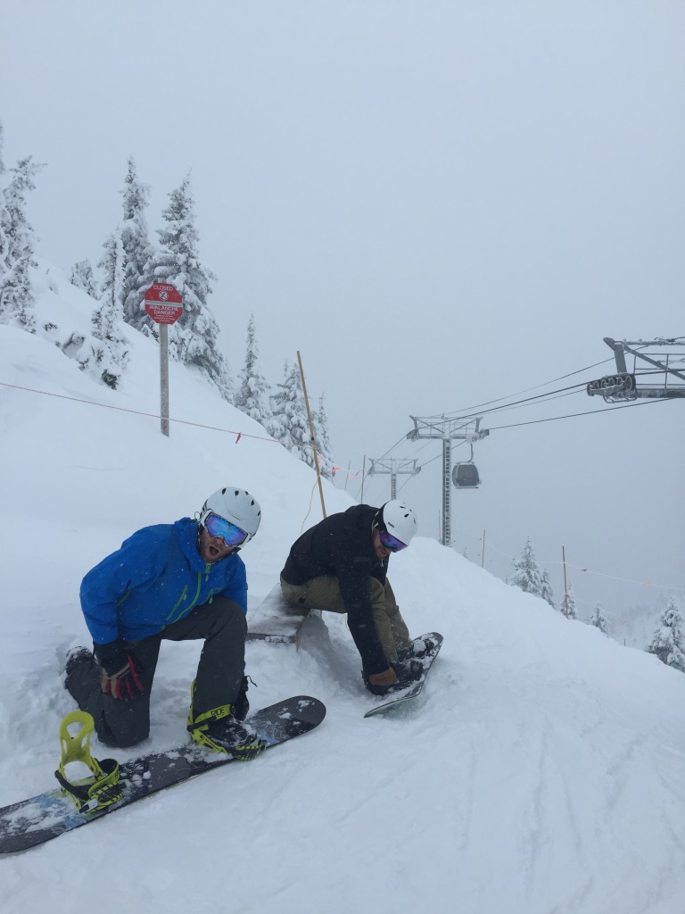
Whistler
Right, so this is one of the great Meccas in the world of
mountain biking, easily top 5, maybe top 3. We easily could have spent most of
the trip in the surrounding area, but the nice thing is, it’s not too long a
drive north of Seattle, it wouldn’t be hard to re-visit. We had picked out the
trail, Comfortably Numb, as the main target, and were interested in Kill Me Thrill
Me too. We scoffed a bit at the advised 3.25 hour ride time on Comfy– clearly the
uphill bike-pushing enduro bros had put a drag on the average ride time on this
trail.WRONG!
Comfy Numb was 3.5 hours of some of the hardest riding I’ve done since I left Saratoga Springs, and the similarly aggressive Stables trail system. Actually, I felt like I was in Stables most the time, except for that whole, huge snow-capped mountains thing. The riding was straight up hard, across the board, and never relented. Every foot of progress was made difficult by features, and the trail climbed and descended relentlessly. On the main descent at the end of the trail, I had to stop two or three times – yes, on the downhill – to take a moment and recover!
I think, however, in total, there were only 3-4 features on Comfy that neither Adam or I felt we could not ride.
Once we finished off Comfy, we didn’t have a clear plan. Kill Me seemed to involve a road ride to complete, and the weather had called for thunderstorms in the afternoon. It was still nice out, but I was certainly feeling worked, and the thought of spending another 3 hours on Kill Me, especially if it began to rain, was not appealing. Instead we rallied a fairly fast loop on the Lost Lake blue trails. It was nice to finally open the bikes up a little bit and pedal, but after Comfy, these trails were the numb ones, boring in perspective. Then we hammered the gravel grind Green Lake Loop trail back to the car, sliding into the trail head just as the rain and thunder began! In retrospect, we should have started in the Village and warmed up on the Lost Lake trails, then ridden Comfy. Hitting Comfy with cold legs was extra tough.
 |
| Dark woods on Comfortably Numb |
 |
| Dork. Look, I'm even wearing baggies! |
Pemberton
Hands down, I had more fun on the Pemby trails than all the
others. We rode part of the NIMBY 50 loop, including the Nimby trail, and then
Middle Earth, which switchbacked relentlessly for something like 3,500 vertical
feet or some such business through a huge variety of forests on a challenging
trail. A Kiwi ex-pat named Grant blew by us on the climb and we latched on to
follow his wheel as he lead us up Nimby and told of us the race they’d soon
have on the trails he was preparing for. I was so jealous. We split at the top
of Nimby, climbing further up the Middle Earth Trail, before charging back down
Rudys. Rudys was probably my favorite trail of the entire trip, incredible flow
with non-stop trail features that made me wonder when the last time was that I
felt so pushed by a trail only rated as blue? Next we dropped down a black
called Rusty Trombone. There was debate about maybe going down Overnight
Sensation next door since that’s the race route, but anyway, Trombone was good
enough. There were probably a half dozen features we walked. Part of the
challenge however, wasn’t just the features, but the very dry and loose trail
surface. We were surfing a lot on the steep trail and it made it tricky to
confidently roll into the steeper features. Next we headed over to the Mosquito
Lake trails, which had a lot of promise, but turned out to be a bit of a mess
to navigate. Pemby could use some improvement on that front, and I hit a wall
on patience with the constant map checking (which btw, the paper map is out of
date) and app checking, all the while, feeding the namesake insect of the local
lake. The long grind of a climb and descent was so satiating, and my hunger was
satisfied. My only other comment for Pemby: you guys have some hardcore trails,
but what’s up with the names? Don’t answer that, I get it, a bunch of dudes, in
the woods, for a long time. Seriously though, sorry to unleash my middle-aged
dad, but the trails are really BA on their own, world class, they don’t need
lame names that a group of 13 year olds and The Donald would think were cool,
or appropriate.
Back down in Pemberton, we found showers in the shiny new
rec centre and watched local kids tear it up in the bike park. In retrospect, I
think we might have spent another day in Pemby and ridden Mosquito Lake with fresh
legs the next day.
We were on the road that afternoon instead on the steep and
winding highway to Lillooet, and onward to Mile 100 House area. We found a place to camp on the shore of Lac La Hache, and temps dove to 26 degrees under the clear cold sky. The next morning we went to check out some low-key single track around Mile 108.

 |
| Such good trail! |
 |
| OK views too. |
 |
| The kids bike park in town. |


Mile 108 is a social trail network and we relied on the app,
but even then, most the trails weren’t shown. The system was small, and really
old school. I really wasn’t into the trails at all. I’m sure they’re awesome to
the local scene, but not worth stopping the car for on a long trip. Next we
headed to Williams Lake, stopping in at the Barking Spider, the local shop, to
get a little fresh sealant for Adam’s weeping rear tire, and a little trail
beta. The staff was extremely nice and offered a route suggestion on their Southside
trail system, which we headed on over to for the second ride of the day.
Unfortunately, less than halfway into the suggested loop, I
broke my drive-side pedal off its spindle. I turned and high tailed it back to
the van to get to the shop before they closed, but Adam continued to ride,
investigating the rest of the South system. Even in my short 1.5 hour ride,
half with a busted pedal, I still enjoyed the trails and liked how easy they
were to rip.The trails we saw were generally very smooth, there’s not a lot of a roots or rocks, though they tried to find some. Compared to the Mile 108 trails, they are vastly better, with good flow, and were easy enough to navigate. The advice from the shop owners on access was integral though, as you have to ride through a narrow, legal corridor, surrounded by no trespass signs, that would turn most people around. We planned to investigate the West Side trail system the next morning, but intermittent sprinkles that evening turned to a steady rain overnight, and puddles were forming everywhere.
We grabbed breakfast at the Gecko Tree – the best food of the trip – along with food for the road, and headed north to Burns Lake, where the weather forecasters promised the rain had passed.
Let’s put this in perspective: In 2011 I drove up with Rachel, we did the trip in three 16-hour days. Burns Lake was our first stop, and we opted to stay in hotels on the trip to get a good night’s rest and early starts in the mornings. Our hotel room in Burns Lake that night had strange, dried-blood-colored spots on the sheets (we slept on top of the linens in our own sleeping bags, thanks much), bugs crawling out the drains, and our neighbors were some loggers so drunk they could hardly stand – accompanied by a few lady friends of theirs of course. If you had told me then, that one day I would sing praises for this small community, and the mountain biking there, I would have laughed my head off.
Our accommodations this time was on the side of Boer Mountain at the trail head in a clean campground maintained by the mountain bike assoc. Much better.
Adam had the logical argument that on a trip like this, it would be better to try. He could not have been more right. We rode some incredible backcountry trails as high as we could, and it was pretty spectacular, and just made me want to go back for more. The snow-capped mountains, narrow and rough single track, thick forests, and general quiet was a welcome relief after several days in the low lands.
Smithers is a drop dead gorgeous place, with tranquil green fields that seem to run right to the base of the wilderness peaks beyond. I’d probably pull up stakes to call a place like this home.
That night, we headed north, and ended up driving about half the Cassiar Highway, before finally pulling off at the edge of a random logging site to call it a night.
 |
| Outside Smithers |


 |
| Rugged backcountry trails. Too bad we were too early for the alpine riding. |

 |
| Dease Lake area. |
I’d heard a lot of good things about WH. Maybe I just had unreasonable expectations, but I thought it was fairly vanilla. In my mind, vanilla is not bad, but, its average. The trail network is extensive, no doubt; the summer weather is a good bit better than SCAK’s, and the trail app developed is pretty solid.
That’s about where my praise ends. Whitehorse, like Anchorage, is the hub, albeit a smaller one, and is pretty seedy. If someone told you they were coming to Alaska to mountain bike, hopefully they wouldn’t spend more than a day or two in Anchorage. It seems like the area beyond WH is begging for a backcountry epic, not just suburban spaghetti bowls. This is the wild north after all, right?
As for the trails themselves, ya, meh: trail markings could be better, and especially seem lacking due to the incredible number of social trails that randomly jut off. Despite having a good app, it’s hard to ride here without having to stop constantly to re-check your route. Worse, some social trails are obviously social trails and you can burn by, while others are heavily used and look like main trails. It’s clear to me anyway, the trails assoc should probably make their priority cleaning the rats from their barn. Sometimes, in smaller trail networks, social trails can help create some variations. For a place that boasts 100 KMs of trail, this isn’t really an issue, and in the process, the trails lack a clean feel. We had to turn around several times when we either chased a prominent-looking social trail thinking it was a main trail, or missed a junction of an actual main trail because it wasn’t marked and looked more like a social trail. It got really frustrating. Additionally, there was evidence of really bad behaviors everywhere, people seem to have no problem making their own cut offs of trail bends or cutting alongside intersections through the open woods.
My other issue with the trails: they’re doomed for erosion problems. The trails generally lacked switchbacks, and attack gradients steeply, frequently. Without much rock in the soil, this is going to go the same way it’s gone for every other steep trail ever built in the history of humankind: a lousy rut. Basically, it’s hard to see this and not think about how much work they will be doing in years to come to re-route and re-build since they didn’t do it right in the first place.
Lastly, Whitehorse’s trail rating system is pretty whack. The blacks seemed consistent enough: steep and rooty. The blues, basically meant everything else, from hybrid double/single track to “why isn’t this considered black?” I got the impression that three different people or entities had rated different parts of the trail system throughout their construction. When you look at a map, you have no way of knowing what you’re going to get out of a blue trail as a result. While I never felt outmatched…their blacks might be Pemberton green…I was really unimpressed when I found some blue “singletrack” really wasn’t blue, or singletrack.
It’s a lot of harsh criticism I suppose, but I guess I
really see the area as otherwise having so much potential and just not
realizing it. I would still go back, but it’s a spring or fall destination for
SCAK – going mid-summer seems stupid, our trails are much better, we just don’t
have the weather.
Anyway we finished off our ride with the thermometer tapping
in the high-70s, and thought we’d rinse off in the Yukon. Well, it may have
been hot, but that water sure wasn’t! 
 |
| The iconic Yukon Canyon trail, def a must ride, I enjoyed this a lot. |

A bit later we were on the road, and made it over the AK border by 10PM. The next morning we were on the road a little after 5AM and back in ANC by noon. Adam and I dumped out my gear from the van, and he headed the final 2 hours to SOL. It was drop dead gorgeous in Los Anchorage, so I jumped on the hard tail and hammered the hero dirt conditions on Hillside, and despite feeling a little emptied from the long trip, quickly felt restored and glad to be home.
 |
| Haines Jct. |
 |
| Well....it WAS clean. |
 |
| 7 hours to home. |
What an incredible trip!