Monday, June 27, 2011

The Russian Loop (Sharon S Rendition) (June 25)

(This is the one of three posts to make up for a general lack of posting over the past few weeks. To see trip reports from Johnson Pass and Eagle River, view the previous two posts as well.

After learning of a convenient detour from Sharon S, I've been looking forward to riding what I've been calling the Sharon Rendition of the Russian Lakes Loop. The Russian is one of my all-time favorite rides, but it has a limited season and late June is typically its maximum before overgrowth makes its impassable and unenjoyable until mid- to late-September.
The Sharon Rendition of this classic starts from the Resurrection Trails south trail head, and heads north on Resurrection 4.6 miles in to the Junction with Bean Creek Trail. The recently rebuilt BCT takes you back to Bean Creek road, which eventually dumps out on the north side of the beginning of the Kenai River at the mouth of Kenai Lake. A short ride over the pedestrian walkway along the Sterling Highway bride gets you across the river, and 50 feet later, it's two pedal strokes across the highway to Snug Harbor Road.
This cuts out the ~5 miles of shoulder-less highway riding I used to do to complete this loop. (In the name of full disclosure, there is probably 1/4 mile ride of highway riding from the Russian River Overflow Parking Lot back to the car...we didn't even get passed by a car when we rode back...)


 Brian, Ethan and I met up at 7:30 Saturday morning after a heavy overnight rain, and pondered the dark, misty clouds rolling overhead. It was too long a drive to risk getting rained out, so we decided to take along fishing rods as an alternate plan.

After driving through on-again off-again rain the whole way to Cooper Landing, we net Kjell at the trail head and found it was cloudy, breezy, and cool, but not raining.
The first half of the ride up Res and up Snug was mostly cloudy, but as we climbed blue sky started to appear.
Dropping down through the upper section of Russian Lakes Trail.
 We found the trail was just past its prime in terms of overgrowth. The trail itself was perfect, not too dry, but really firm. It appeared the rain had not made it to the upper section overnight so in some places it was actually dry. Vegetation was handlebar-high in some of the usual suspect meadows, but as a whole was still OK. Riding would have been ideal for the last three weeks, but July 4th will be the absolute latest for sure, and I won't be riding it.


The shores of the Upper Lake.


Some fields that are typically really grown up were still surprisingly low, a pleasant surprise for sure.

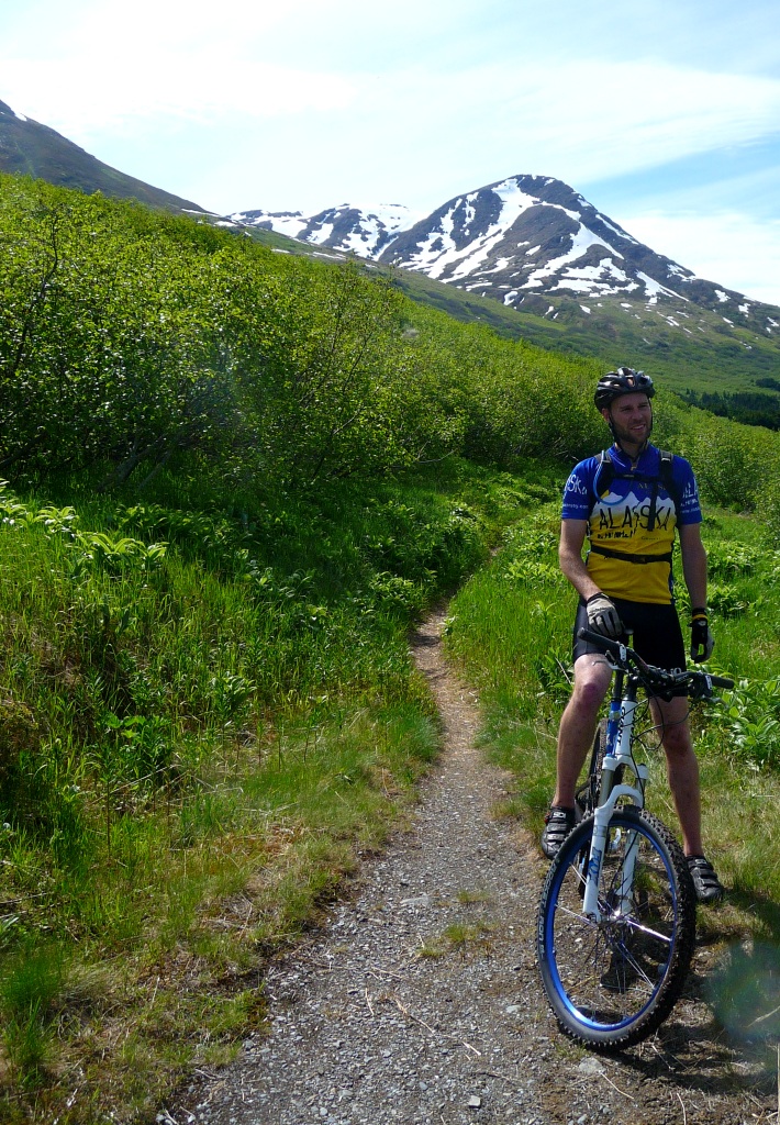
Such a classic June on the Kenai shot.


A quick break on bug cliff.


The avalanche slopes were blooming.


We cleaned the 42-mile loop in 5 hours, 40 minutes, and that accounted for some messing around at the end to deal with a quick flat and hanging out at Russian River Falls. Ride time was probably 5 hours, which is pretty good.
Done early, we decided to give it a go on the Russian River for sockeye. The fishing was pretty slow, but the crowds were limited too and it was actually a pretty nice and peaceful experience, which s not something that can often be said for that area.

Johnson Pass, both ways (June 18)

Johnson Pass is a Kenai springtime epic. The 23 mile trail's north end is largely open and gets overgrown as plant life kicks into photosynthetic overdrive, making it nearly impassable and unenjoyable. The north-end also sees more snow than the south-end, so its a narrow window to get in and out.
Often this trail is ridden one-way with a shuttle, and while that would yield a rather short ride compared to some of the other Kenai epics, the north-end in particular is rough and challenging in places and can suck it out of you.
Mike C, Ethan, Kjell, and I decided to hit it in both directions, starting from the south-end and riding north, planning to turn around at Turnagain Pass. The grind took 8 hours and change, though was slowed a bit by a major mechanical at the pass. I believe actual ride time was in the 6-hour neighborhood.


 Ethan gets a lot of credit for planning ahead and bring a jug of water to leave at the north-end, which we had to drive by on the way to Moose Pass, so we could refill without having to risk drinking untreated stream water. Good thinking indeed, but his preparedness unfortunately did not benefit him.

Temps were in the mid-70s when we rolled out at 10 with the sun shining bright. We weren't too upset that a storm was brewing to the south.

Lark Mountain.


Johnson Lake.

We stopped for lunch at Johnson Lake. Only seconds after leaving from our break spot, Ethan's rear hub unexpectedly gave its last. Ethan was the hero of the trip, coasting (which involved a lot of walking and running) back to the truck, and hanging out in bug-infested Moose Pass while we finished out the ride. Oh, and that water, well, Mike, Kjell, and I were pretty happy to quench our thirsts with his good thinking.


The fabled Alaskan grizzly ground squirrel. Known for their fierce demeanor, they will charge unprovoked!

The north-end has some sweet old bridges.

Shoe for perspective.

On the return trip through the pass clouds had moved in. While the temp didn't go down, we appreciated the relief from the sun.


Kjell borrows a pair of binocs at the pass from a fellow traveler to scope a nearby slope for bears. None seen, but how many saw us?

Mike rides along the last five miles above Trail Lake with lupine blooming everywhere.

South Fork Eagle River with Amy (June 12)

Amy S flew in from Middlebury on June 11 to head north and teach a month-long course for NOLS in the high Talkeetnas.
After making the rounds through Anchor-town Sunday morning, we headed toward the Mat-Su Valley where the NOLS Alaska branch is based in Palmer, with a planned stop to do a little warm-up hike.
We headed up to the end of Hiland Road in Eagle River to the South Fork trail head where we found the lot full. No surprise, free parking in Chugach State Park on a nice day goes a long way. The good news is, most people don't. Once we crossed Eagle River on the map marked in the map below, we didn't see too many others. I was vaguely familiar with the area. Jack and I made some turns there in December (LINK) and the valley has good touring when conditions are stable. Some of the farter back peaks are also Front Range mountaineering classics.
We hiked 5 miles back to the end of the glacial cirque. I had intended to shoot off into a side valley to a sheltered lake but missed the entrance.


The South Fork Valley viewed from a bench at the bottom of the hanging valley we hiked up.

The sub-summit of Hurdygurdy Mountain. Ya, that's really its name.

Looking back down the central moraine that leads to the top of the cirque.


Triangle Peak.

Calliope Mountain.