Wednesday, April 29, 2015

Northeast Pinnacle Couloir and Other Fun in Fairangel

Creative credit for this one goes to Kyle…kinda.
Kyle sent me an email suggesting we ski a couloir northeast of Pinnacle. He even sent me a nice map with the line, front and center. I read the email as “the” line NE of Pinnacle, and never opened the map. I was in.
In the end, it didn’t really matter that we were talking about two different neighboring lines, as the target valley was the key.
Though Hatcher hasn’t picked up even a fraction of the snow that’s fallen to the south this past month, I had a suspicion snow was still accumulating in very manageable amounts in the higher reaches, and would we’d thus not have the same, scary, stability issues plaguing the Kenais.
It was nonetheless pretty funny when we finally made the corner into Fairangel, and I had my eyes on NE Pinnacle Couloir, and Kyle had eyes on the big cross-cut couloir he had initially been thinking about, and we both realized, we’d been talking different lines.
Though the cross-cut couloir is spectacular – a surprisingly straight and wide chasm that runs diagonally across a massive cliff wall – its orientation is almost due east, with a lot of tilted southern exposure. We could see pretty quick it was catching a lot of sun.
That was no worry, the NE Pinnacle looked dark and cold!
Joining us for the adventure was Nathan R, who had some summertime experience climbing in Fairangel.
We had debated access, with the options being to either come up and over from Independence Mine, using the NW Pinnacle couloir for the climb, or making the much longer approach via Archangel Road.
Kyle and I used skate skis to access the neighboring Webfoot Valley back in January, but with spring in full effect, we knew the road would be frozen hard and rutted up in the morning, and slushy and soft on the way out. Skating pack-less would have been miserable in these conditions, so skating in with loaded packs was pretty much guaranteed knee surgery.
Though the NW couloir up-and-over was appealing for its brevity, we decided the long way in was the safer option as it would allow us to assess the snowpack and the condition of the line on the way in – after all, this is Hatcher Pass in a thin year.
We were cruising across the rock hard and icy road nice and early. The sun was out, and we made descent time to the end of the road.
I was shocked we were only passed by one skate skier the whole way. While the road was horrid, everything else was bomber crust. In my mind, if we failed to find powder, I’d already resolved to return with skinny skis the following day.
I guess skate skiing really is dying.
We didn’t have to go that far into Fairangel to start finding nice pockets of protected powder, even at the valley’s base, and as soon as we started climbing, we realized we were in for some great skiing.
The higher we climbed, the better the snow got.
By 1130 we were lined up beneath the apron of the NE and ready to start the climb.
Kyle and Nathan broke the skinner into the bottom of the gun barrel, where Kyle dug a quick pit.
We found over a foot of light density powder well bonded to a thick crust. Below this was the early March snow, and beneath that, another layer of crust covering the Hatcher Pass square powder base we’d been skiing all season.
The line had seen light to medium amounts of sloughing from snow bombs, though nothing too significant.
I strapped on the Verts and started the climb.
The line featured no real protection until pretty far up. Within the last 75 feet there were two “roofs,” however, they afforded  minimal protection, and the second roof sported a Buick-sized overhanging cornice no one was excited about going under.
Along the way, the snow took on a slightly more packed-powder feel, though promised to be very edge able.
I continually probed for hollow layers below, scared we’d push onto slab, but never found any.
Kyle took the last pitch, which required an interesting wiggle maneuver between the small ridge cornice and Pinnacle’s rocky face to top out.
There was just enough real estate for the three of us up there.
After the climb, and looking down into the NW Couloir, I was glad we’d made the long approach. The NW looked like it might have been a little crusty up top from wind and sun. More importantly, we had some critical beta, and confidence in our line. The entry was intense, and required side-slipping between the cliff face and cornice into the 50+ degree pitch, and within three turns, cleaning a crux created by a partially buried cliff band that sported some bedrock just begging to tag our bases or worse.
Nathan dropped first.
The firmer packed powder higher up skied beautifully. I was surprised by the amount of slough Nathan moved. He got through the crux without finding the bedrock, and as he entered the lower portion of the couloir, we knew we were in for a treat: huge flumes.
Kyle went in next, and I got to take the coveted T-Rice honors.
I kept my line to the right, up on the fin, the entire way down. The snow was largely unsettled there, and I was in a near continuous powder cloud.
The intense entry and incredible snow that followed had my adrenaline on high the whole way; through most the run I had a steady flowing stream of dry slough tumbling alongside.
I could not have been happier with the way the line skied when I got back down.
We finished out the run through the rest of the bowl, and stoked on the snow quality, went back up and skied from the couloir’s mouth back out to Archangel.
Cruising back down the road in shorts and t-shirts on afternoon corn wasn’t bad at all.

The NE Pinnacle Couloir as seen on Google Earth

Nathan checks the outhouse at the end of Archangel for wolverines.

Target in sight.

A chimney wiggled between these two granite summits and made for a nice ski the next day.

Mouth of the couloir.
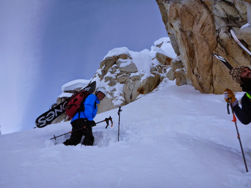
Poke poke.

There was just enough space for the three of us on the small ledge at the top, and I was standing on a slight rock shelf.

Looking westward toward Goldcord Peak.

Oh ya, and then there was this guy...a nice Buick-sized conice perched on a hot rock. Nice.

Nathan


Kyle
Ya...I was a little stoked at the bottom!

Perfect.
 

I headed back into Fairangel solo on Sunday. With the weather forecasted to be a carbon copy of Saturday, and confident in the area’s stability, I was comfortable with being alone.
I’ve hardly done any solo days this season, and though they’re not a great habit to get into, when conditions line up, I find they offer their own set of rewards.
I wanted to first check out the cross-cut couloir before it had too much time to cook, and then spend the rest of the day playing in the dark and cold shadow of the ridge that separates Fairangel and Webfoot.
I knew going in that the cross-cut line probably wouldn’t be a full-go, but I wanted to poke at it. Surprisingly, the first 500 feet of the line was in good condition: about 2-6 inches of slough that was the consistency of cream cheese on a rock solid, but carvable base. I ended up climbing a titch less than half the line, broiling in the sun the whole way. Just a little shy of midway, the snow changed suddenly, and consisted of a little over a foot of un-sloughed, wet, slabby, mank, with a crunchy untransformed layer immediately below that, and more layering deeper down.
Aside from concerns about how stable this top layer was, I knew ski quality was going to get worse, so I parked on a big exposed rock in the middle of the run away from the walls, and transitioned.
Skiing the full line will remain somewhere on a mental list, and would make a good spring objective in another 2 weeks, but is otherwise probably better reserved for mid-winter.
The lower portion of the line skied really well anyway, but I was happy to scoot over into the cold and dark side of the valley and get out of the infernal sun.
I had my eyes on a short, but very steep chimney that split two granite peaks. As I began the boot in earnest, I was impressed by how much snow the chimney held as I wallowed thigh deep, even with verts; and was further impressed by its steepness.
I don’t need to say it skied really great right?
I dropped all the way back down to the base of the valley for a nice long powder bowl run, and then headed back up, and broke a new skinner on a slope between the chimney and the east buttress of the Pinnacle to have a recon look down into the Upper Webfoot-Fairangel Crossover Couloir for a future tour.
By the time I reached the ridge, the efforts of the past two days had finally caught up with my legs.
The snow was really nice on the climb though, and I savored the moment, knowing this would very likely be my last powder run of the season.
Though the day before we had heard the echoes of voices from a number of skiers and even a couple of snowmachiners down in Archangel, been passed overhead by a parade of small planes; today had been markedly quieter. Except for two planes earlier in the morning, I hadn’t heard another human-generated noise all day. Sometimes, the sound of a distant tumbling rock would echo, and some ravens had made a brief ruckus later. That was it. I could list all the sounds I’d heard in the past 6 hours on one hand.
With that, I pushed the nose of the board over the lip, took one more look around, and dropped in:
One,
More,
Time.

Halfway on the cross cut looking up. While rollerballs littered the surface of the snow, above this, it hadn't sloughed out or fully transformed yet.

Looking down. The line was probably stable, but the shade and powder across the way beckoned.

Another view of the Pinnacle.

Reverse view of the cross-cut from the chimney. I turned around just above the rock about midway.


Looking over Webfoot and Syndey.

Looking down the snowy chimney.


Third run, taking a peak down the Upper Webfoot-Fairangel Crossover Couloir.

Taking it in.

Monday, April 27, 2015

One Hour Slower or 10 Minutes Faster

On my left, a long-running fracture extended as far down the ridge as I could see. Toyota Tacoma-sized chunks of cornice that had partially peeled away from the slope hung like seracs; and far below them, I could spot the toe of a wide pile of debris spilling over into treeline, indicating the entire CFR bowl had ripped.
On my right: football fields-worth of minutes-old avalanche debris covered the entire valley floor – the same floor that had dominated my view for the past hour and a half, and was uncovered for all of it.
Our tracks and transition zone from the previous run on the slope and flats to the right were wiped out and buried.
It appeared we were on the only 50-foot strip of snow for at least ¼-mile in either direction that had not slid or been buried.
I was convinced there was no way we’d get back to the car without getting tangled in some kind of slide; something terrible had happened, the magic hour had struck, and this mountain was shaking off a layer of 4-5 feet of snow like a dog shakes water from his soaked coat.

-

Kyle and I were skiing the north side of Tin Can. We’d just done a rather conservative run, skiing down part of CFR ridge, and then dropping north lower down on the ridge where it begins to broaden.
Snow conditions below 2500’ were 2-3-feet of heavy and wet toothpaste-like snow with a breakable wet crust on top. Above that, the snow was deeper, dryer, but still dense, with a slight wind or heat crust on the top.
Conditions weren’t great, but they were consistent.
With a hazard rating of moderate for treeline and up, 19 inches of new snow mid-week, and no observed avalanche activity since the prior weekend, if you had asked me what my main avalanche concern for the day was prior to 2:00, I would have said: “wet slide point releases on sunny faces that could run 2-3 feet deep, probably slow and molasses like, but heavy enough to hurt or bury you in the wrong spot.”
That wasn’t a big concern, as our target aspect was northerly/westerly out of any direct sun.
We weren’t thrilled with the snow, but it was nice enough to stay out.
For run 2, after deciding the crowded and sun-baked south side skinner slope looked…crowded and sun baked, and not seeing a compelling reason to not at least try, we decided to poke into one of the north-facing chutes.
Kyle and I were skiing down into one of the western-most chutes, an uncomplicated affair that rolls over like a basketball at the top. We planned to post-up on the exposed ridge that looks down into it – there is no way to have eyes on someone after the chute rolls – but that would be a good enough spot, with the plan that I would head down into the valley below, and radio back up to Kyle as to how it skied. If it was better than what we just did, he would follow, if not, he could head down the ridge, and we would re-group below in the flats near our previous transition spot, and probably just go home.

A photo showing much of the extent of the 4/17 Tin Can slide, the crown still visible 4 days later following a 2-3 day storm that dropped over 3 feet of snow and delivered triple digit wind gusts. Photo: CNFAIC

Heading to the exposed rocks overlooking the chute, I couldn’t believe my eyes: It looked like all of Todds had ripped, burying the entire valley floor. For a half second, I thought the debris was still moving, but realized it was static. I could see where it arced out of the chute I was skiing into, as well as maybe those above (east) of it.
Delayed for that second or two, I cut hard back to the ridge line, and started waving in that direction for Kyle to follow.
Four riders had just headed down the ridge as we topped out, and I was convinced there was a burial, maybe multiple, below.
A good full account was compiled by the Chugach National Forest Avalanche Info Center here as to what happened next. (Kyle and I were the party of two that followed the group of 4 that triggered the slide) http://www.cnfaic.org/site/observations/tincan-avalanches-off-the-north-and-south-side-of-cfr-ridge-3/

-           

It’s been a bit of a challenge to make sense of this event.
Perhaps one of the most troubling aspects, aside from the narrow margin of time that separated Kyle and/or I from being wiped off the map by this slide, is that it’s been difficult to point to anything in particular that should have warned us of the scope of the danger that day. As a result, it’s not clear that I can say that given the chance to repeat the day, I would have made any decisions differently.
Here are the take aways I’ve landed on so far:

  1. Deep wet slab on persistent bed surface in late season
  2. Unpredictability
  3. Late season snow: too much too late
  4. Solar heating
  5. Consistent, but not great skiing
Most these issues are somewhat inter-related, and the differentiation, and their individual significance can thus seem hazy.
Here’s what I can say about 1 and 2.
We’ve been dealing with a persistent though stubborn melt-freeze layer since early April that has proved to be a poor bonding surface. A number of large slides have reacted on this layer since the beginning of the month, and given the progression of the season, it’s shown no signs of healing.
It’s pervasive, and exists literally across much of the Kenai range. As a result, its ability to allow slides to propagate on an enormous scale, connecting disconnected terrain features and letting slides go “wall-to-wall” across entire mountain sides, is shocking, and scary. It’s now buried deep under the accumulated snow of early April (12 feet?) (number 3).
When I first began to grasp the scale of the north-side slide, my mind, landed on the Twin Peaks slide that went naturally in 2011 and took out much of the face of that mountain (http://www.cnfaic.org/site/observations/silvertip-creek-twin-tip/). Later, Kyle noted the well-known skier-triggered slide on Sunburst in 2008 (http://www.cnfaic.org/accidents/avy022308.htm), and I think that was a better comparison.
On a smaller scale, in late March 2013, a similar bed surface formed in the Summit Pass region. Snow did not accumulate heavily in the region in the month that followed, however, there was enough accumulation to result in a number of very unpredictable natural and skier-triggered slides through out that zone, though fortunately, because of the overall lack of accumulation, and perhaps the colder temps of that spring, slides were smaller in scale, both in depth and width. Regardless, in light of this season, the lesson learned, was that the persistent weak layer never healed.
The way 1, 2, and 3 blend together, is that we had a nice, heavy, wet layer on top that, in theory, would heal and stick. The lack of avalanche activity the preceding days certainly would have indicated this was occurring. Perhaps, earlier in the season, this is a concept that can be relied on more, but late season, with more daily solar heating, the layers were getting diurnally stressed.
Big dumps to the scale of what we saw this April aren’t uncommon here, but are more typical from late October through late January. Then we have cold days and repeated poundings by violent coastal gales that help glue the snow on to the mountain sides or knock it loose during the heights of the storm cycles, we get good stability.
Ideally, in March through April, good skiing comes from smaller snowfalls (less than 3 feet), and less violent distribution events. Indeed, looking back, the best late season years I’ve known have been characterized by cool springs and a consistent line-up of weak storms.
Looking back on this April, I would describe avalanche conditions as hard to evaluate, and lethal if misjudged.
I think this wording will help stick in my mind. We ski some lines with a lot of risk. I’d like to think we user all the available data to determine if that risk is worth taking. In this case, basically, the data was far too variable.
On number 4, Kyle and I thought we were mitigating the effects of solar heating by skiing a slope out of direct sun. What perhaps we failed to account for in this situation, was the presence of a layer of high, thin clouds, and a nearby storm cell over Portage, that were likely helping to push heat onto all aspects, as opposed to just those in the sun’s cross hairs.
Then there is number 5. I would not have described conditions as extremely variable, so I wouldn’t call this a “system overload situation” (http://atrailcalledlife.blogspot.com/2015/02/avalanche-awareness-false-alarms-and.html), in fact, conditions were rather consistent, just, not good.
What I’m gathering from this, is that my experience levels in the backcountry tend to fall under a rather specific condition set: cold powder. This isn’t surprising, these are the best riding conditions for the most part, and in general, I will seek out and confine myself to the aspects and elevation bands that best support this type of riding condition. As this last comment gets to the point of “duh,” my remark is, in choosing to ski snow conditions that are different (a wet slab, as it was on this day) I should really back up and re-think how I’m making decisions and what criteria I’m using to evaluate stability, and realize that what I may take for granted at other times, may not hold up. More and more, I tend to ask, why even ski in these conditions? That’s harder to answer though after you’ve driven down, skinned up, the sun is out, and the season is drawing to a close.

-

Thanks to all those that have let me chew on their ears (or screens) to talk this slide out. That pretty well includes everyone I know it seems. I hardly landed on these takeaways on my own, and it was quite distressing feeling like there weren't any solid lessons learned. While its still bothersome that there weren't any big red flags that were missed, I think it can be said there were some situational circumstances that can hopefully be used in the future.

Thursday, April 16, 2015

Three Lines; Alaska Range 2015

Last fall when Aaron asked me if I was interested in doing another ski trip to the Alaska Range in April, I had about a .00001 second delay before I said, “yes.”
I regretted not doing a ski trip last winter, and Aaron does a phenomenal job herding cats (skiers) and taking care of the planning and logistics required to spend a comfortable week in the state’s most defining range.
Photo: A.H.

We headed into the upper Buckskin glacier, an area not heavily frequented.
Assembled on the tarmac in front of a Talkeetna Air Taxi turbine otter, pilot Paul came over and took one look at our gargantuan pile of gear, and started laughing – it’s no wonder hardcore climbers make fun of skiers.
Paul mentioned that, “we might get a little bit of precip,” in the coming week, but the wistful way he said it reminded me of how we at fish camp used to tell clients, “we might get a bite,” when the fishing was horribly slow.
We knew a storm was lined up in the North Pacific, but we were uncertain as to how it would impact us, if at all.
Fresh from a day of skiing deep, north-facing pow in Turngain just 12 hours prior, Paul’s comment seemed to confirm my pessimistic fear that we’d find wind-hammered conditions and limited soft snow. I assumed he was just trying to plant a seed of hope for us.
Despite the pile of junk we shoved into the Otter, along with the 6 dudes and Paul, that badass bird launched off the runway like it was empty.
I love those planes.
Paul gave us the royal treatment, and said he’d give us a fly-over of the zone to point out various lines he’d skied, and then let us decide where we wanted to plant ourselves. We were super grateful for this.
We chose to get dumped higher up the glacier, closer to the base of Mooses Tooth, and a suite of bigger and steeper AK Range-style lines.
Lower down, we would have had the option to do a good deal of proud skiing, but would have also found some more gradual “pillow” terrain in between.
As we entered the foothills, I pressed my face against the plexiglass bubble window, studying the mountains for clues, cracks, fractures, wind striations.
Honestly, snow conditions looked fairly benign.
As Paul banked hard against the steep mountain walls and brought us down, I had my face smooshed so hard to the window it’s sort of a wonder one or the other didn’t break.
I watched as the plane’s skis finally hit the glacier snow: powder flumed and the struts sunk lower as the engine throttled back.
“Huh, this is a big plane with a big engine and fat skis…they can probably power through anything,” the pessimist in me thought.
Paul killed the engine and jumped out of the cockpit.
As he walked by the plane, he waded through knee-deep, soft snow.
“Holy f#^k!!!”
We strung out along the wing and unloaded the plane.
Paul continued to point out various lines we should check out, and doled out ample info on persistent wind direction, and the best configuration for camp, and perhaps more importantly, where he wanted his runway.
He mentioned the storm again, noting that it would probably, “come from over there,” he said, pointing to the massive Tooth.
He mentioned he’d be flying back over us today with a group of sightseers, and after taking another long look around, pointing again to a particular summit he said we needed to ski, he climbed back aboard the Otter.
“You guys are gonna get some serious snow,” he said, before slamming the door and throttling up the engine.
You can imagine, at this point, I was kind of confused. Were we going to get a few inches, or should we be thanking our lucky stars Aaron found that grain shovel on the side of the highway?
Time would tell.
With 6 people, camp set up was a breeze. Prior to construction, I’d probed the area out, and needed nearly the entire probe to hit the ice below.
Camp, by the way, is a bit of a misnomer; compound might be a better descriptor.
By 2:30, we were done.
Time to ski.
We roped up and headed toward the Tooth, aiming for some north-facing terrain.
We eventually picked a really nice fin that had a NW aspect to it, and low (by AK Range standards) over head or downslope hazards. We headed a short ways up the and dropped a pit.
The results were the best thing a skier can hope for: About 6-8” of dry, fresh recycled pow was relatively poorly bonded to another 12-18” of recent snow, which was well-bonded to a solid and deep base.
The surface 6-8” was too dry or light to cause a concern, and although it was faceted both above and below, it proved to be of little concern.
We topped out the fin and enjoyed a fantastic evening run back down.
With a track in place, heading back to camp was an easy cruise in split ski mode.
Paul flew back overhead while we headed home and had a look at our tracks.
It felt like we’d arrived in paradise.

Yeah, we had a lot of stuff.


Paul told us to ski off this.

Which looks like this. The big inset couloir is massively tempting too.


Paul gave us a lot of beta. Photo M.G.
Mike makes the pee spot.

Camp set up went quickly with many hands.

Let's go ski! Photo A.H.
In a haste to take off we forgot to secure camp from the ravens. I turned tail and sped back to their dismay, but got this shot of the crew about a mile off

From the top of the fin looking back toward camp. Paul pointed to the hanging snow field past that as another good ski, though its approach aspect would have been crusty.


Kicked in at the top of the fin. Photo M.P.
Kellen drops in.

Paul takes a look at our tracks.


Sunday dawned with high, broken clouds.
A cluster of more easterly facing couloirs north of camp caught our eye, and we headed back up the valley.
The chosen line of the day again posed little overhead hazard, though part of the “apron” was a nearly 100-foot cliff with a large hole below. It was easy to avoid, but this is the way the AK Range is: even your most straight-forward, low-light, low hazard conditions, would still love to kill you if you biff.
The snow in the line looked good from a distance, and indeed, the apron was creamy and soft, but within the white granite chambers, we found that sloughing caused by falling debris from above had transformed the snow to punchy. The upshot was that the slough gave the snow a great visibility component, and the overhead hazards had long since fallen.
Matt, Aaron, and I punched up it while the rest of the crew did a hot lap on a neighboring apron. The snow conditions hardly warranted the maximum effort, and we turned tail a few hundred feet above the apron as we realized conditions would not improve farther up. We dropped to rejoin the group.
While it was survival skiing at best, I didn’t mind it, and when Kellen, Mike, and Kenny said they’d like a stab, I was glad to take advantage of the kicked-in booter and hit it again.
I actually felt a little better on the second run, but there wasn’t much question, while most of us survived, Kenny slayed the line.


A side view of the target couloir. Photo A.H.

Photo M.G.

The choke consisted of a rock-hard slough bed.


Kicked in.
 
Monday, the clouds had sunken low around the glacier. Vertical was pretty well out of the question, but with our eyes set on one of the peaks Paul had pointed out a few miles away down glacier, we figured we’d set ourselves up and punch the 3-4 miles lateral track into its base so we could glide down and hit it once the skies popped.
It was actually a pretty good use of the day. We got as close as we dared to the and increasingly jagged edge of the glacier in the flat light, and stopped for lunch, admiring an obvious and deep couloir that spurred from the summit line.
We knew we’d have to do a bit more route finding to get into the apron of the line, but also knew we’d be better served to wait for better viz.

Photo A.H.

:Lunchtime

Tuesday morning broke much like Monday with low clouds.
Kenny optimistically proclaimed “it’s gonna go blue.”
As we ate breakfast, the sound of falling snow ricocheted off the tent walls. We looked outside: snow-poccalypse had started, and basically didn’t give up for another 60 hours.
Winds through the snowfall were mostly light, though a brief interlude did create a noticeable layer about mid-way down.
For the most part, the snow fell the way one would hope, on the heavier side.
The camp held up great, the deep trenches and high walls did their job in capturing and blocking the snow, and dig outs were fairly easy, aided by the grain shovel.
Late on Wednesday, a break in the storm gave us a hopeful glimmer of the surrounding mountains. The pillow lines on the south-facing slopes north of camp promised to deliver some fun skiing once the skies began to clear off for real.
In the meantime, reading, writing, sleeping, eating, and Monoploy Deal filled the hours, along with listening to the thunderous avalanches that poured off the north-facing cliffs on the south side of the glacier.

It's gonna go blu...shit.


Wednesday morning.

Six sweaty dudes stuck in a tent for days. No but really, this is how I spend my off time.
 
By Thursday, the storm had finally begun to retreat, and we were all eager to ski, despite the lingering clouds and snow showers.
Depending on aspect, slopes had picked up 2-3 feet.
We headed first for the south-facing stuff near camp. I headed up the middle of a fin we planned to ski, feeling the remnant, choloupa-taco sun-crust layer closer than preferred. About 30-feet up the slope, I triggered a deep collapse 3 feet down that resonated strongly downslope. More than likely, the slope only held thanks to the stout crusts and the many giant boulders acting as anchors. With ample glacial traps beneath us, it didn’t add up. I’d planned to get a little more upslope to drop a pit, but here was as good as any. The slope had probably collapsed on a buried sun crust, a foot down from the previous surface crust, now 3 feet down from the surface of the new snow.
We cruised a few miles back, stopping for lunch close enough to the Tooth it hurt to look up at it, before continuing further back to a face loaded with giant, tempting couloirs.
Nearing the gateway of one of the couloirs, Kenny, Kellen, and I spread across the apron and dropped a pits, not wanting to go farther up and crap our pants again.
The results were a little variable, but showed that beneath the new snow, the surface layer we had skied on day one was problematic. The new snow was failing at an ECPT of 15-20 with a Q2-3 shear…not bad. The problem came on the next hit. In almost every pit, one more hit after the storm snow went, the former surface layer, now compressed to 4-6 inches of brittle syrafoam, popped clean with a Q1 shear.
Below this, we were finding more complicated layering on east and south aspects than we found on the north/west, indicating potential to step down further. With the clouds thickening and snow flurries intensifying, we headed back home, stopping at the fin we’d skied the first day to see what the story was there.
Basically the same thing, sans the more complicated sun crust issues, though the storm snow was 3 feet or deeper on this aspect.
Another day and some cooler temps seemed to be needed to boost bonding and confidence. For now, we had a textbook picture of a stressed out snowpack.

Headed toward the Tooth.

The lower half of a highly-desired couloir. Above the clouds the line split into a massive bowl with 5 fingers above that reaching some 3,000' to the ridgeline. For perspective, we're at least 20 minutes just from the very base of the apron.

Another pit.
 
We faced a new dilemma though. Mike’s wife had sat-texted us the forecast for the coming days, and it appeared a weak storm was on the horizon.
Even with another day to bond, it seemed like a bad idea to go for one of the big lines we’d eyed (not to mention the track we’d busted down glacier was long gone). At best, we could hope for skiing some isolated fins or low-danger aprons on Friday…terrain that while fun, is hardly iconic. In doing so, we would risk getting stranded in the tents for our planned pick up date on Saturday if another storm moved in.
We decided to check in with TAT Friday morning and get their prognosis.
Overnight, a light, cool wind blew, and temps dropped, helping to consolidate the fresh snow. Overhead, we were dazzled by an amazing aurora display.
When we awoke, the clear skies had been replaced by a low cloud and snow flurries with viz less than 100 feet.
TAT told us they could get us either day, though the pick up would require a viz window. No sooner did we get off the phone did the clouds began to peel off.
Exercising restraint, and noticing the giant bank of clouds down glacier, we opted to go pack the runway. If the clouds were still at bay when we finished, we’d head for the slopes, if they moved back in, we’d probably have to cross our fingers and hope for another window, or plan for another day of hanging out at camp.
We probably only got ¼ of the runway in before the cloud bank rolled in as thick as it ever had. Viz was back down to 100 feet or less.
We packed out a big strip, and went back to camp. For another hour and a half we sat around.
The trip was obviously over.
Around 2, the cloud lifted again. The bank of clouds down glacier looked a little less threatening, and we called TAT again and asked for the pick up.
Camp tear down was about as efficient as set up, and we had time to spare before Paul cruised in.
It was depressing, for me at least, to stare at all the lines and all the slopes, to know that they were there, but that they would have to wait for another day, and fill my dreams until then.
We were treated to a cold but brilliant display Thursday night. Photo A.H.
My camera can't match Aaron's.


Bummed. Photo M.G.

Camp tear down. Photo M.G.


Back to civilization. Photo M.G.
 It’s easy to get lulled into the rhythm of weekend adventures in the country and terrain 1-2 hours from Los Anchorage.
It’s easy to forget that the glacier-clad peaks on the north and west horizons of the city aren’t that much more of a drive, plus a short plane hop away, and yet, they exist an entire world away.
While I think we all had our hopes for the trip dashed by the powerful North Pacific low that set up shop in Southcentral Alaska, we were still lucky to spend time in a place that serves as a compelling reminder of why some of the best skiing in the world is found here…and how insignificant a scratch on the surface most of our adventures really are.