It's late July on the Kenai and no one is questioning that. The Sockeye are entering the river by the 10's of thousands every day, King fishing is good and trips to the salt are freezer filling.
On Monday night alone Angelo and I processed about 650 pounds of fish between 6 p.m and midnight!
Suffice to say, I don't have more more to write about, so I'll post this little piece I had run in the Clarion last week:
Shhh, the salmon are listening, they can hear you, I swear.
Unlucky hats and bananas be damned, if there's one way to scare off a lite king salmon bite, I'm positive it's a little too much ego in the morning.
OK, so maybe there are other factors that play into one's success hooking into a king, but in my limited experience, overconfidence never helps.
I still remember the first time I saw hubris dull hooks.
My dad and I were fishing the spring run of the mighty Rogue River a decade and a half ago or so with a friend of his named Ken.
It was my first time fishing for kings and I had no idea what to expect, but Ken did, or at least so he said.
Ken had lived and fished all over much of the globe, including right here on the Kenai. At the time however, he was living in Oregon.
As we made the long drive from his home near Bend to Gold Beach, I remember him saying, "Mmm, I can taste that king salmon off of the grill already."
I distinctly remember thinking, how does he know we're going to catch one?
While I'd never fished for kings, I'd sure spent enough time with a hook in the water to know that you can't taste a fish you haven't caught unless you're planning a stop at the grocery store on the way home just to be sure.
Meanwhile, I just hoped I'd be so lucky to see one of these mega-salmon that could grow to half the size of my 12-year-old frame.
Wouldn't you know it, we spent five days on the Rogue and got two take downs that resulted in one fish in the box.
I was indeed so lucky; Ken, not so much.
I'd like to say that's only the case for fishing the Rogue, but my experience on the Kenai has showed me otherwise.
You get all types at fishing lodges like the one I work at, and I've seen no shortage of guests that stroll in talking much like Ken.
It might just be me, but I've noticed it's those folks that don't know what to expect, and are just hoping for a chance to catch a fish, that usually go home with a box of Kenai king steaks and memories to last a lifetime.
Meanwhile, the brash guest in the cabin next door is typically heard muttering about the price of a fillet from the grocery store.
Tuesday, July 20, 2010
Tuesday, July 13, 2010
Mount Ascension
Pete, Doyle and I skied off the top of 5,710' Mt Ascension, just outside of Seward on Monday. Conditions were epic for mid-July. We had bluebird skies, breathless wind and corn that rivaled the best of May.
View Larger Map
Pete and I had been discussing the idea of getting the glaciated north side of the peak that towers nearly 4,000' above Lost Lake for the past week. The current weather cycle for the last couple of weeks has been dismal though. We're caught in the wash cycle: 2-3 days of rain, followed by a 12-36 hour window of nice weather between storms. The good news, the snow's just not melting and there's skiing in places that are normally lush tundra this time of year.
The rainy Eastern Peninsula is no exception. The ultra popular Lost Lake Trail still has remnant patches of snow on it, and the lake itself is holding a slushy covering of ice around its shores.
As a new storm rolled in Friday evening, It began to look like the stars, the moon, my work schedule and Southcentral weather were about to combine to produce a clear window Sunday through Monday and give us just enough time to make the accent and more important, descent, a reality.
Then, as if on cue, I got hit with the worst stomach bug, no wait, the only stomach bug, I've had in 10 years. Suffice to say, it knocked the you don't want to know what out of me that night and left me laid up and in rough shape Saturday despite the fact that we had 80 people in camp for a corporate tournament.
It looked Ascension was off.
After a long day, I slept for 12 full hours Saturday night and awoke feeling much like the sky above Sunday morning though, with the sky breaking apart and a sun starting to shine down.
The forecast was perfect, I called Pete and we planned to head to Seward in the afternoon.
 I stole this nice map from Keith, who climbed the peak last July with Edie, Emily and Kyle. Thanks Keith.
 We hit the trail around 5 and headed up to the alpine lake.
 Doyle, up on the plateau looking for a good spot to camp.
 Pete.
Pete.

 A little after 10:30.

 The next morning we headed up the bench below the peak, climbing for maybe 45 minutes including a stop to fill up on water before we made it to a good linear patch of snow that we could skin on.
 Doyle, with Ascension's summit field looming above.
 Pete, with a sub-summit behind him. Doyle destroyed the climb, blasting upward on his skins to the last foot of snow. Pete and I had our tails between our legs though. About 2/3 the way up the summit field, we opted to scoot across to a vertical band of scree and scramble the rest of the way up to the skyline ridge.
 The snowfield clawed up the mountain's neck to within about 200' where we left our skis and scrambled the remainder to the top.
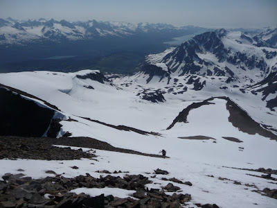 A good view of the summit field descent with the glacial bowl to the left.
 The top.
 The Harding Ice Sheet with Exit Glacier in the center right.
 Looking west we could see all the way to the Central Peninsula with Skilak Lake in the distance.

 Lost Lake, with the south end of Kenai Lake past that and the aptly named Snow River Drainage beyond that.
 Looking north we could see all the way the mountains north of Turnagain Arm and had it been a little bit clearer we might have seen the Alaska Range. To the south we could see into the Gulf.
 Tony shreds.
 The descent was simply awesome, our timing was perfect and we dropped down bast the glacier before the snow really began to get sticky.
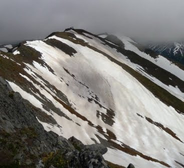
 The fog bank eventually lifted enough and we were able to ski to within about 100' vert of the trail by skiffing over tundra to connect up snow patches.
View Larger Map
Pete and I had been discussing the idea of getting the glaciated north side of the peak that towers nearly 4,000' above Lost Lake for the past week. The current weather cycle for the last couple of weeks has been dismal though. We're caught in the wash cycle: 2-3 days of rain, followed by a 12-36 hour window of nice weather between storms. The good news, the snow's just not melting and there's skiing in places that are normally lush tundra this time of year.
The rainy Eastern Peninsula is no exception. The ultra popular Lost Lake Trail still has remnant patches of snow on it, and the lake itself is holding a slushy covering of ice around its shores.
As a new storm rolled in Friday evening, It began to look like the stars, the moon, my work schedule and Southcentral weather were about to combine to produce a clear window Sunday through Monday and give us just enough time to make the accent and more important, descent, a reality.
Then, as if on cue, I got hit with the worst stomach bug, no wait, the only stomach bug, I've had in 10 years. Suffice to say, it knocked the you don't want to know what out of me that night and left me laid up and in rough shape Saturday despite the fact that we had 80 people in camp for a corporate tournament.
It looked Ascension was off.
After a long day, I slept for 12 full hours Saturday night and awoke feeling much like the sky above Sunday morning though, with the sky breaking apart and a sun starting to shine down.
The forecast was perfect, I called Pete and we planned to head to Seward in the afternoon.
 I stole this nice map from Keith, who climbed the peak last July with Edie, Emily and Kyle. Thanks Keith.
 We hit the trail around 5 and headed up to the alpine lake.
 Doyle, up on the plateau looking for a good spot to camp.
 Pete.
Pete.
 A little after 10:30.
 The next morning we headed up the bench below the peak, climbing for maybe 45 minutes including a stop to fill up on water before we made it to a good linear patch of snow that we could skin on.
 Doyle, with Ascension's summit field looming above.
 Pete, with a sub-summit behind him. Doyle destroyed the climb, blasting upward on his skins to the last foot of snow. Pete and I had our tails between our legs though. About 2/3 the way up the summit field, we opted to scoot across to a vertical band of scree and scramble the rest of the way up to the skyline ridge.
 The snowfield clawed up the mountain's neck to within about 200' where we left our skis and scrambled the remainder to the top.
 A good view of the summit field descent with the glacial bowl to the left.
 The top.
 The Harding Ice Sheet with Exit Glacier in the center right.
 Looking west we could see all the way to the Central Peninsula with Skilak Lake in the distance.
 Lost Lake, with the south end of Kenai Lake past that and the aptly named Snow River Drainage beyond that.
 Looking north we could see all the way the mountains north of Turnagain Arm and had it been a little bit clearer we might have seen the Alaska Range. To the south we could see into the Gulf.
 Tony shreds.
 The descent was simply awesome, our timing was perfect and we dropped down bast the glacier before the snow really began to get sticky.
 Just on time, a new storm was working it's way in from out of the Gulf. We watched as clouds were pushing over the farthest southern edges of the Peninsula while on the summit, and as we dropped off the glacier, a thick bank of fog rolled in our of Resurrection Bay obscuring everything.
We picked our way through the obscurity and soon enough the angle of repose fell enough that I split my board and went into tele mode as we worked our way back around the mountain trying to stick to our climbing route and avoid a deep gorge.
 The fog bank eventually lifted enough and we were able to ski to within about 100' vert of the trail by skiffing over tundra to connect up snow patches.
From camp, the tour took about 5 hours.
Tuesday, July 6, 2010
Rainbows and butterflies
It's official, I've completed all of the Kenai Epics. On Sunday Justin and I rode Johnson Pass, a 23 mile point-to-point I'd only ridden half of, some 6 years ago when I first visited this place.
J-Pass runs north-south, in a glacial valley directly east of Summit Pass and the Seward Highway, connecting the village of Moose Pass with the south end of Turnagain Pass. We often look into this area for spectacular views when skiing in Turnagain in the colder months.
View J-Pass in a larger map
The trail, a popular Kenai backcounty mountain biking epic or multiday backacking trip, was part of the original Iditarod Route.
Justin, aka the MacGyver of the Kenai, and I had been talking about riding J-Pass for a a few weeks as a 46 mile out and back before it got too grown in.
That was the game plan when we left Sterling on Sunday morning. I was particularly excited to ride the south end of the trail too as I had only ridden the north end so many years ago and skied a short section of south end in November of '08 (LINK).
 LV Ray Peak across Upper Trail Lake.
 Justin rides along the lake's rocky shore less than a mile from the southern trail head.

Unfortunately, Justin was feeling the effects of a long week both on the bike and in the office. At 9 miles in, just a mile shy of the pass, he decided it would be best if he turned around and headed back rather than risk really running himself into the ground. I carried on to the end with the plan that he would meet me at the northern trail head.
I wasn't too keen on splitting, but I trusted Justin's decades of experience to get him back safely. Despite it being a holiday weekend, we'd only seen three people in those nine miles.
On a separate note, it's also of great value to have riding partners who know when they need to call it off rather than putting both people or a group at risk when they should back down and play it safe. Justin's call was much appreciated, though going from having a partner to solo in a place where 8-10 inch (across) brownie tracks are a common sight can leave one a bit mentally rattled for a few miles.

 Johnson Lake.
 The Pass.
 Bench Lake.

 A familiar sight. Once over the pass I was on familiar ground. Six years ago, I descended the 13 miles back to Turnagain "solo" on the last day of my 6 day mountain bike adventure. The ride was a real turning point for me I've always thought.


 A very familiar sight, the sunny side of Turnagain.
 Not surprisingly, there were four remnant snow field in slide paths, all of them within 2.5 miles of the northern end of the trail. A cool summer and above average snowfall in Turnagain Pass last winter has left snow in places where it's not usually seen in July.
 I finished the trail in an elapsed time of 3 hours and 50 minutes. For comparison, last fall I rode the 40 mile Resurrection Pass Trail from south to north in about 5 hours elapsed time (photos, snacks) and I don't think my riding speed is much different, just the terrain.
On Monday the wind was ripping but the sun was out, so Rach, who was down visiting, and I climbed Cecil Rhodes Peak, a 4,405' peak that towers above Cooper Landing. There is no actual trail up Cecil, just a herd path that goes straight up.
 Breaking out of treeline and looking westward through the Upper Kenai's valley.
 The climb is the definition of an SFU accent.

 Shoots bursting through remnant snow at ~2,800' on July 5.


 Cooper Mountain's north face ice bowl and summit buried in clouds directly above.

 As we approached the ridge a rainbow formed over Cooper Landing with it's two ends at either end of the mountain village. Now you know.
 I stuck the camera out over the edge of Cecil's northface, which plunges nearly a full 3,000' vertical feet back down to the river. A 40+ MPH wind was tearing across the ridge while we lay on the craggy rock.


 A goat was hogging the summit. This guy sat on his perch watching as we approached him to within 20 yards before he finally sauntered down the craggy northface to a spot he knew we'd never venture and proceeded to have a snack.


 Iron cross on the summit.

 A repeater site on Stetson Peak.
 Summertime in an Alaska forest.
J-Pass runs north-south, in a glacial valley directly east of Summit Pass and the Seward Highway, connecting the village of Moose Pass with the south end of Turnagain Pass. We often look into this area for spectacular views when skiing in Turnagain in the colder months.
View J-Pass in a larger map
The trail, a popular Kenai backcounty mountain biking epic or multiday backacking trip, was part of the original Iditarod Route.
Justin, aka the MacGyver of the Kenai, and I had been talking about riding J-Pass for a a few weeks as a 46 mile out and back before it got too grown in.
That was the game plan when we left Sterling on Sunday morning. I was particularly excited to ride the south end of the trail too as I had only ridden the north end so many years ago and skied a short section of south end in November of '08 (LINK).
 LV Ray Peak across Upper Trail Lake.
 Justin rides along the lake's rocky shore less than a mile from the southern trail head.
Unfortunately, Justin was feeling the effects of a long week both on the bike and in the office. At 9 miles in, just a mile shy of the pass, he decided it would be best if he turned around and headed back rather than risk really running himself into the ground. I carried on to the end with the plan that he would meet me at the northern trail head.
I wasn't too keen on splitting, but I trusted Justin's decades of experience to get him back safely. Despite it being a holiday weekend, we'd only seen three people in those nine miles.
On a separate note, it's also of great value to have riding partners who know when they need to call it off rather than putting both people or a group at risk when they should back down and play it safe. Justin's call was much appreciated, though going from having a partner to solo in a place where 8-10 inch (across) brownie tracks are a common sight can leave one a bit mentally rattled for a few miles.

 Johnson Lake.
 The Pass.
 Bench Lake.
 A familiar sight. Once over the pass I was on familiar ground. Six years ago, I descended the 13 miles back to Turnagain "solo" on the last day of my 6 day mountain bike adventure. The ride was a real turning point for me I've always thought.


 A very familiar sight, the sunny side of Turnagain.
Despite what I remembered, it turned out the south side of the trail, which I'd been told was overgrown and rough, was much more enjoyable than the northern side. The incessant rains this year have left it slick in places and the poisonous cow parsnip was thick in some of the meadows.
 Not surprisingly, there were four remnant snow field in slide paths, all of them within 2.5 miles of the northern end of the trail. A cool summer and above average snowfall in Turnagain Pass last winter has left snow in places where it's not usually seen in July.
 I finished the trail in an elapsed time of 3 hours and 50 minutes. For comparison, last fall I rode the 40 mile Resurrection Pass Trail from south to north in about 5 hours elapsed time (photos, snacks) and I don't think my riding speed is much different, just the terrain.
 Justin pulled into the parking lot just 15 minutes after I got off the trail and only a minute after I'd finished my smoked salmon sandwich and was preparing to hit the road. Justin chugged water after turning around and combined with the descent, began to feel much better making for enjoyable rides for both of us.
On Monday the wind was ripping but the sun was out, so Rach, who was down visiting, and I climbed Cecil Rhodes Peak, a 4,405' peak that towers above Cooper Landing.
 There is no actual trail up Cecil, just a herd path that goes straight up.
 Breaking out of treeline and looking westward through the Upper Kenai's valley.
 The climb is the definition of an SFU accent.
 Shoots bursting through remnant snow at ~2,800' on July 5.

 Cooper Mountain's north face ice bowl and summit buried in clouds directly above.
 As we approached the ridge a rainbow formed over Cooper Landing with it's two ends at either end of the mountain village. Now you know.
 I stuck the camera out over the edge of Cecil's northface, which plunges nearly a full 3,000' vertical feet back down to the river. A 40+ MPH wind was tearing across the ridge while we lay on the craggy rock.

 A goat was hogging the summit. This guy sat on his perch watching as we approached him to within 20 yards before he finally sauntered down the craggy northface to a spot he knew we'd never venture and proceeded to have a snack.

 Iron cross on the summit.
 A repeater site on Stetson Peak.
 Summertime in an Alaska forest.
Subscribe to:
Posts (Atom)