The last 2 weekends have been a dream of blue skies, calm winds, and creamy snow. Conditions in Hatcher are primo. The snow pack is thick and stable. Better yet, much to the dismay of winter weary Alaskans, temps have been below average, preserving the powder goodness.
It seems my endeavors have been focused on a few shaded drainages in the Hatcher area, so if all the pictures here have a similar look, forgive me, but I tried to choose different angles from different days.
Sweet entries on the bowl run in Stair Stepper
Smiles in the sun.
Finding the deep in a corner pocket.
It's fun, but you don't have to yell "Geronimo." Actually, please don't.
Reverse view of the corner pocket run.
Time to go home.
Looking across the street from Stair Step, the Government Peak area beckoned. On Tuesday, Aaron and I cut out of work early to go investigate.
Overwhelmed
I planned to climb Frostbite and wrap around to the summit of Government, but as we got our first view of the backside of Frostbite, well, plans changed.
I want it.
Like flies drawn to the light, we passed by a bunch of ripe lines and went to a corner pocket with a 10-foot cornice that demanded a 15-foot mandatory entry. It was intense, so we pulled out some rope and tried to cut the cornice down a bit.
An hour and a half of wasted time later, we gave up. The good news was, that cornice wasn't going anywhere, depite several deep cuts.
An alternate entry would have been to make a much smaller drop onto the rib, but little cookies poking out suggested this could be a rocky landing.
So we found other things to do with the remaining daylight,
The thought of the corner pocket line and all the good lines we passed by lurked in my mind while I tried to focus on work the rest of the week, and by the time Friday rolled around, I was ready to go back. Aaron had to work a half day, but this still allowed plenty of time to get done what I had in mind.
The north face of Government: loaded.
I was focused this time: right back up Frostbite, I had my eye on a techy little line right off the top that someone else had already layed a single set of tracks in.
Then head up valley and climb Government.
Drop it.
Climb back up the backside of Fostbite and ski down one of the north chutes.
Cruise back out.
All in enough time to get Aaron home for dinner.
Dropping in off the top of Frostbite. Photo courtesy of Aaron.
Good look back up Frostbite; and boarders get the bad rap about chewing up the mountain!!! Look at those tight little turns! Photo courtesy of Aaron.
Another view of the rock bands.
Summit Ridge of Government.
Frostbite's north chutes. Short but fun.
Bowl behind Government. Sun baked.
Booting to the summit.
Oh...I see my entry line!
Valley view.
Not a bad Friday.
Saturday, a small crew headed to Stair Stepper with the plan to head into Delia Creek.
Nathan dropping a run. Photo courtesy of Lizzy.
About to make my own sweet drop into Stair Stepper.
Reverse view of the above two shots. Photo courtesy of Lizzy.
Sadly, while I was skinning up the ridge between Delia and Stair Stepper, my right binding broke. After an initial onslaught of f-bombs, Nathan pulled out a ski strap, we braced the broken piece, and I spent the rest of the afternoon working on my tan...and yelling at everyone else to ski harder!
Close up of the damage taken later on back at home.
Chillin.
At least I had good company!
Because of the way the bindings mount in ride mode, I was able to board out pretty easily.
Delia Creek head waters.
Sunday, with a spare set of Voiles mounted, I think we had some big aspirations, but ended up lapping what was left of the untracked terrain in Stair Stepper and chasing butterflies around with no clothes on, proving there is no such thing as too much of a good thing...I think the sun must have got to us.
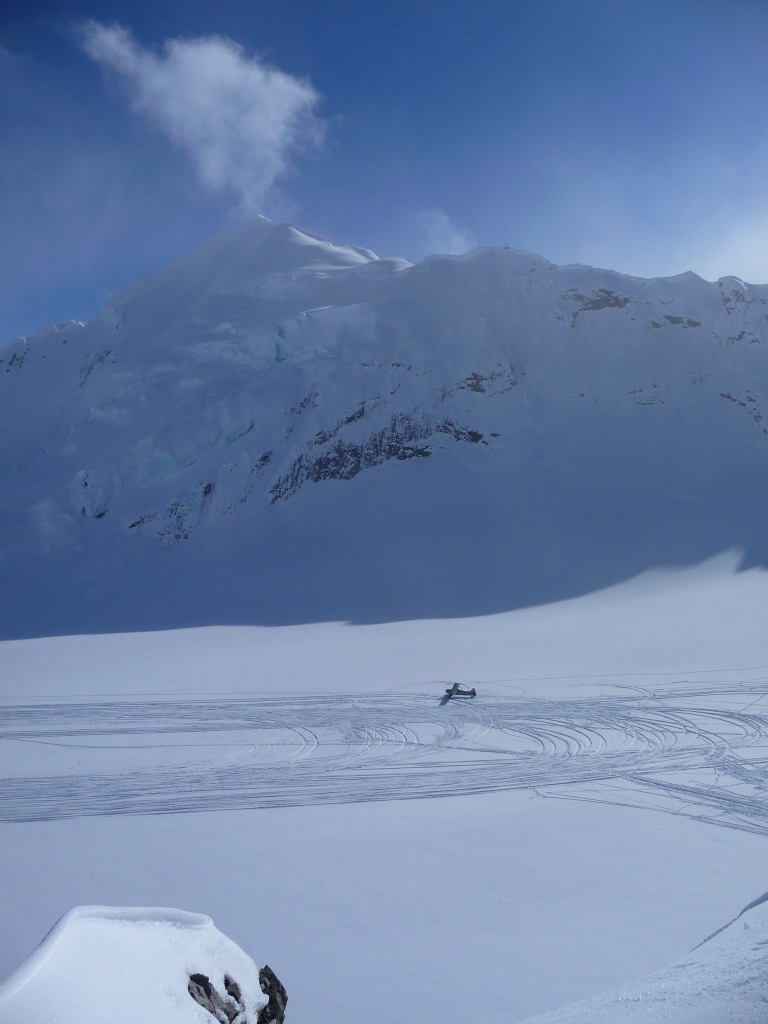
Earlier this winter Mi Ke sent me an email and asked if I would be interested in joining a ski trip to stay at the Don Sheldon Hut in the Ruth Amphitheater in the Alaska Range. For my non-AK readers, this tiny little private inholding in Denali National Park and Preserve is a hexagon shaped hut that sits on a steep rock outcrop in the middle of the glacier with sweeping views in all directions including of Denali.
I was weak on glacier travel, but Mike and the assembled group said that would be OK. This was a ski trip, not a climbing trip, and in truth, we all knew that the Alaska Range is a climber's mountain range, not a skier's so we would probably so as much touring around and sight-seeing as actual vertical skiing.
We were initially scheduled to fly in on Sunday April 7, but an approaching storm, and a cancellation from a group that had planned to stay in the hit only Saturday night, lead trip organizer Aaron to make the call to try and get in on Saturday.
It mean for some late-night packing an early morning on Saturday, but is was absolutely the right call. Had we not gone in Saturday, we would not have made it in until Monday, and we were scheduled to fly back out on Thursday. When we awoke Sunday morning it was puking in Anchorage, but as we drove north out of Wasilla it stopped, and Talkeetna was blue.
Loading up.
We flew in with Talkeetna Air Taxi, and we got to go in on one of their turbine Otters. The single-engine planes are the aviation equivalents of Suburbans, and can haul a lot of gear, people, and go to some rad places.
All smiles as we go airborne.
Getting our first look on the way in.
The hut, empty, before we moved in.
The hut sits may 100 feet above the glacier landing strip on a rocky outcrop that juts up through the glacier. It's about a 5 minute hike from the plane. The out-going group was waiting on the strip when we landed, and left a log in the wood stove and melted water.
Welcome home.
The hut is insulated and heated with a wood stove. Most people bring in duraflame logs as they pack the most BTUs per pound compared to wood. It's easy to turn the little hut into a Swedish sweat sauna.
The landing strip from the hut.
Mt. Dickey behind the hut.
After a couple hours, having got settled in, we headed across the amphitheater to Tele Haven, what appeared to me as a small bump perhaps a half hour tour away.
Tele-Haven is to the right.
Looking back at the strip and the hut.
Mt Barrille and Dickey
Well, lesson 1: The AK Range is huge.
OK, I mean I knew this, and I tried to prepare myself, but when the boots and skins hit the ground, it finally became apparent.
The half-hour skin took about an hour and a half, and the "little" bump offered a pretty solid 900+ feet of vert, with more options up valley.
We roped up for the glacial traverse, but once we hit the base of Tele-Haven we dropped the ropes for the climb.
Grouped up on the sky line ridge, the ambient felt like it was in the low 20s and we started to get pumped.
360 view from the top of Tele-Haven.
Aaron takes off for first tracks.
Launch. Yours truly. Photo courtesy of Mi Ke.
Yours truly on the descent. Photo courtesy of Aaron.
Karson
Mi Ke
Tony
The snow was about ankle-deep, dry, and fairly fast, on a carvable base. We went back for seconds before roping back up to head home.
Headed back home, soon to enter the shadows.
On the trip back we learned lesson 2: this range can be cold. A week ago I was riding my road bike on the Anchorage hillside in afternoon temps that were tapping the mid-40s. As the sun dropped below the jagged horizon on our skin home, temps plummeted, and an inversion began to set in place. Temps were easily in the single digits and we realized we had stepped back to a climate more like what we see in January.
The boys were just jealous of my Australian school boy uniform, even if I was comfy in the hut.
Day 2 we headed out for a tour to 747 Pass. This tour provided us with a great view of some amazing terrain. Clouds blew up the glacier in banks but the sun stayed out for the first half of the day.
Roping up. Photo courtesy of Karson.
Broken Tooth and Moose's Tooth.
A side view of Mt Barrille.
Is this a rock outcrop, or a nearly 4,000 foot vertical wall of rock forming the eastern face of Mt Dickey?
Looking up into 747
At the base of 747, Aaron and Tony climbed up the first ramp to make a run. It was getting late and we needed to turn around. As they went out of sight, another bank of clouds rolled in. This time though, it didn't blow out, it just started to blow.
They skied back down in the flat light.
We turned around and headed back out to the main glacier, with vis rapidly decreasing.
Mi Ke lead us four hours back home, carefully picking our hardly visible track out of the flat light. It was grueling, and the only 2 things we had going for us was that a. vis was still descent enough to catch glimpses of major land marks from time to time, and b. the blow was really just a delicate sneeze by AK Range standards. So, Lesson 3: this range is real, and even a little day tour can turn into a survival trek in the right conditions.
All lessons we already knew, but there's nothing like some ground truthing I suppose.
Mi Ke dropped one of the best quotes of the whole trip later that day.
Hours later, back at the hut, having lead us for hours despite half-hearted offers from others to take over or flip on the GPS, and visibly fatigued and a bit stressed, Mike walked into the hut, and in one fell swoop of his left arm and perhaps two long strides, grabbed a beer from under a bench, popped the top, plopped down on a bench and pounded half of it in a couple gulps, and then, looking at no one in particular but still making it clear he wanted it to be heard, said,
"I gotta take a sh!t."
We died, the tension was lifted.
Drying gear.
Breakfast time.
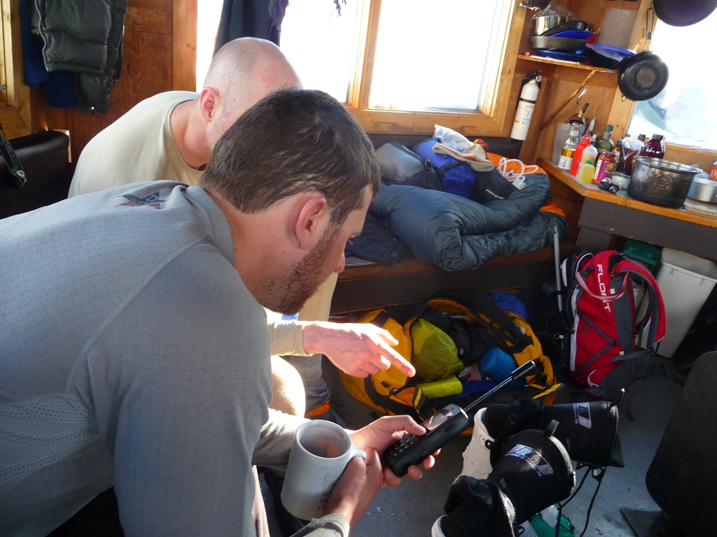
making sure we all knew how to use the Sat phone, for emergencies, or heckling people...
Day 3 Aaron had his sights set on a couloir 20 minutes from the hut. We could see it had a shrund, and crevasses around the apron, but we decided to investigate.
The crevasses were big enough to pose serious consequence if things went wrong, but over all, the run looked good and the shrund was filled in. We brought wands and staked out the fan so if we had to make the drop in flat light (we were learning...) we could still charge through the apron and avoiding slough while funneling back through our probed exit.
Our couloir was in the shadows to the right.
Karson's feet were torn up so he opted to watch us from the hut and take a rest day while Tony, Mike, Aaron and I set off. Just above the shrund the snow went from nice to breakable, and Mike and Tony split off and dropped back down to watch us from below.
Aaron and I made it about 2/3 the way up, and wouldn't ya know it, high clouds rolled in. We made it to a point where the couloir was getting both wider and steeper, and the snow ever harder, so we called it good.
Making the transition from skin to boot packing. Photo courtesy of Karson.
Making the transition from skin to boot packing. Photo courtesy of Karson.
Not a fun place to hang around. Photo courtesy of Mi Ke.
Headed up. It was 40+. Photo courtesy of Mi Ke
Looking down. Tony and Mike are little specks.
While we were climbing two planes came in. No planes had come in the day before, and we had seen no one else since Saturday. The planes dropped off Andrew McLean, Noah Howell, photographer Garrett and Andrew's long-time ski partner Mark.
They stopped up at the hut later to have a brew and trade intel.
Flat light skiing.
The storm continued through the night and into the next morning, so we laid low until early afternoon.
Sleeping in.
The Powderwhores Camp. Photo courtesy of Mi Ke
Then around 1 it began to open up, so we headed behind the hut for a few low-angle laps. The skies opened up even more, and soon, Tony, Aaron and I were headed toward what I think is called Michio Point and a cool looking bowl.
At the top of the bowl, looking at a steep outcrop of Mt Barrille.
Nice view point.
The bowl held excellent snow, and we did a warm lap. At the bottom, the McLean crew rolled in. It was a real treat to get to share a slope with these guys.
Aaron skies the ridge.
Couldn't resist a huck.
We tracked this ridge out pretty good.
Andrew skis a line along the Barrille ice fall.
Aerial view of what we were skiing. Bit of a drop to skier's right...Photo courtesy of Aaron.
As the afternoon wore on the temps continued to drop, and water vapor began to crystallize in mid-air, forming one of the biggest sun dog I have ever seen.
The gut shot down Barrille is a big gully that will eat you up and spit you out, but looks so tempting.
Amped up after such a great afternoon and with the skies clear, we were ready for a big last day over at Tele-Haven
We ate really well the whole trip.
Alas, it was not in the cards. The winds picked up over night, and we awoke socked in. All day it blew and snowed, until finally clearing mid-afternoon. Aaron joined with the McLean crew and headed across the way for a lap, but found marginal conditions there.
Clearing skies in the evening.
We were in for a treat though.
Aurora over Denali. Photo courtesy of Aaron.
I joined Mi Ke and Tony, who chose to fore go the hut through the trip and slept in a tent and snow cave, respectively, each night. I set up my biv, and even though it was easily 20 below, passed out. Around 2, Aaron was awoken by light flooding the hut, and came out to take the above photos. His oohs and ahhs woke me, and when I peered from my cocoon I was blown away by the most beautiful aurora display I have seen since I moved here.
The next morning we awoke to crystal clear skies, it was the day we were hoping for, but we had to pack up and head out.
The plane came in on time, and we enjoyed a great ride out, with a bonus pit stop at the Root Canal to drop off some climbers.
Taking off from Root Canal.
Getting a closer look.
Unloading. I love that the Suby could practically fit in an Otter.