An hour and 10 minutes after my alarm went off for the first time on Friday morning, my phone rings. I fumble to answer it but drop the call. Good.
Five minutes later it rings again, this time I get it. Justin on the other end asks: "Want to go crust ski and hunt ptarmigan on the other side of the inlet?" "How long do I have?" I answer.
Warm weather has been promising to set up some great backcountry crust but it hasn't wuite gotten good here yet.
An hour later I'm some how at the airport parked next to Justin's Super Cub shoving skis and poles into the back as the bright morning sun beams down on us. Five minutes later we're off the runway in a helicopter take-off, headed west to the other side of Cook Inlet.
 Soldotna.
 Kenai.
 A steaming Mt. Redoubt.
 Nikiski.
 Mt. Spur.
 A hazy Denali and Foraker.
 Looking for a place to put down.
 The other side of the inlet is packed with swamps, many of which would be best measured in miles.
We put down in a massive swam next to the Kustatan River.
 We skied a ways up the swamp before cutting through the alders to reach the river, passing by one of the the probably dozen or so eagle nests we'll pass in the next 40km or so.
 Click to enlarge.

 Beaver tracks on the right, see the tail drag? We also saw some massive wolf tracks and a coyote ran across the river in front of us. (CTE).
 (CTE).
 Spur in the background. (CTE).
 (CTE)
(CTE)

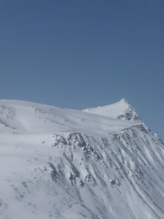
 Decapitated Redoubt.
 After skiing a rip fast 40km out and back we returned to the plane for a lunch in the sun. It's kind of like coming back to your car after a day in the back country, except, it's a plane.
 We flew over the alpine bench above where we were skiing to look for bear dens, but all we saw were mountains, moose tracks and maybe a wolverine track. Darn.


 Nature makes its own designs using big brushes sometimes.
 A plane loaded with fuel for a remote village takes off from Kenai.
 Kalifonsky Beach.
 Kenai.
 Tsalteshi. The Wolverine trail head is lower left. (CTE).
View Summit Peak in a larger map
 Coming up over the knoll and into the top of the basin we skied for the rest of the day.
 There were no end to beuatiful lines, but while the pictures here would say otherwise, we were socked in most the day and stuck to the trees where we had some depth perception in the flat light.

 Check out this wall of snow rolling in from across the pass.
 A ptarmigan on a rock in the middle of the bowl in the middle of the white out became the anmesake of the bowl for our party as it was the exact marker of where to go to find an untracked little grove of hemlocks that was otherwise invisible in the obscurity. (CTE).
 If it wasn't for the top of that hemlock, would you even know that Karl and Jared were on the ground?
 CTE).
CTE).
 A job well done.
 The express route back to the highway. A 2,500' vertical foot straight shot descent on slab ice to Summit Lake. No thanks, I'm not ready to die.
Five minutes later it rings again, this time I get it. Justin on the other end asks: "Want to go crust ski and hunt ptarmigan on the other side of the inlet?" "How long do I have?" I answer.
Warm weather has been promising to set up some great backcountry crust but it hasn't wuite gotten good here yet.
An hour later I'm some how at the airport parked next to Justin's Super Cub shoving skis and poles into the back as the bright morning sun beams down on us. Five minutes later we're off the runway in a helicopter take-off, headed west to the other side of Cook Inlet.
 Soldotna.
 Kenai.
 A steaming Mt. Redoubt.
 Nikiski.
 Mt. Spur.
 A hazy Denali and Foraker.
 Looking for a place to put down.
 The other side of the inlet is packed with swamps, many of which would be best measured in miles.
We put down in a massive swam next to the Kustatan River.
When we get out of the plane we find the snow is crisp enough to support us bare booted with a 2 cm layer of fresh hoar frost on top. Excitement ensues as we race to suit up and get on our skis.
Are we about to be the first people to crust ski the Kustatan? I await my answer from the greater Alaska ski community.
Are we about to be the first people to crust ski the Kustatan? I await my answer from the greater Alaska ski community.
 We skied a ways up the swamp before cutting through the alders to reach the river, passing by one of the the probably dozen or so eagle nests we'll pass in the next 40km or so.
 Click to enlarge.
 Beaver tracks on the right, see the tail drag? We also saw some massive wolf tracks and a coyote ran across the river in front of us. (CTE).
 (CTE).
 Spur in the background. (CTE).
 (CTE)
(CTE)
 Decapitated Redoubt.
  After skiing a rip fast 40km out and back we returned to the plane for a lunch in the sun. It's kind of like coming back to your car after a day in the back country, except, it's a plane.
 We flew over the alpine bench above where we were skiing to look for bear dens, but all we saw were mountains, moose tracks and maybe a wolverine track. Darn.


 Nature makes its own designs using big brushes sometimes.
 A plane loaded with fuel for a remote village takes off from Kenai.
  Kalifonsky Beach.
 Kenai.
 Tsalteshi. The Wolverine trail head is lower left. (CTE).
Not to be outdone by Friday, Kasilof Karl and I met up with Coast Guard Jared and went on an exploratory mission to one of the northerly slopes of Summit Peak in Summit Pass.
View Summit Peak in a larger map
We made a very sketchy ascent on the east face that would earn the respect from climber aspiring to summit The Tall One: rock hard unbreakable crust with slippery wind facets on top. Jared earned an unintended 100’ of vertical descent when he slipped on a steep traverse and was only stopped in his free fall by the grace of a well placed willow. The bruise will heal.
Around the ridge we found boot top powder from the summit down. Varying viz left us alternating back and forth for 5 runs between bowls when the sky opened, to tree runs when all hell broke loose and the snow came down in curtains. Jack W and a friend were skiing the same bowl though we were out of sync, we did share beta on lines as our paths crossed. The bowl is massive, a party of 5 showed up and though many lines were had, there was plenty of powder to go around. We only touched one of three skiable faces in this particular bowl; three more bowls of like nature are to be had to the west.
To exit, not wanting to die down the east fase, we skied the hiking trail out. What a treat, that comes from a split boarder who had to convert to a free heeling telepalooza-er for the gradual down hill tour out. Coming up over the knoll and into the top of the basin we skied for the rest of the day.
  There were no end to beuatiful lines, but while the pictures here would say otherwise, we were socked in most the day and stuck to the trees where we had some depth perception in the flat light.
 Check out this wall of snow rolling in from across the pass.
 A ptarmigan on a rock in the middle of the bowl in the middle of the white out became the anmesake of the bowl for our party as it was the exact marker of where to go to find an untracked little grove of hemlocks that was otherwise invisible in the obscurity. (CTE).
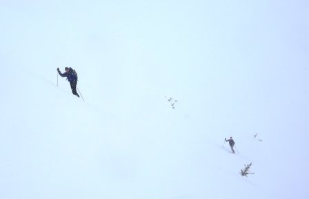 If it wasn't for the top of that hemlock, would you even know that Karl and Jared were on the ground?
 CTE).
CTE). A job well done.
  The express route back to the highway. A 2,500' vertical foot straight shot descent on slab ice to Summit Lake. No thanks, I'm not ready to die.


