I've long looked at the Dry Creek area of the mountain as a potential powder stash, and credit goes to Tony D who hooked me up on the secret little hunters path that snakes up to the otherwise trail-less alpine valley.


The hike started by crossing Dry Creek on a shaky cottonwood that Rach said "No way!" to.
On the way back I demonstrated proper cottonwood bridge crossing technique for the camera. Video Courtesy R.S.

We bushwhacked up through a dense hemlock forest whose loamy floor was bursting with insects.

Out of treeline the growth was head-high and the bugs only got worse.

Getting higher, we got a view or Axis Peak.

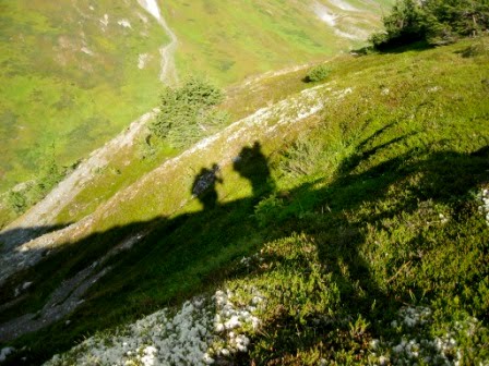
Can you see all the bugs? I'm not promising I didn't just eat one. Photos: R.S.
We stayed high above the creek. Photo: R.S.

Before we eventually leveled with it and crossed to get to a knoll we camped on.

A flock of a half dozen sheep or more was grazing on a nearby slope.

Camp, with the rock crusted Axis? glacier pouring into the tarn.
The bugs were absolutely nuts, and of course, neither of us brought dope. Rach thought she'd film this nice sunset scene, but unaware that she had the record button down, I decided to opine on what I hoped the cold night air would do to the blood thirsty fiends. Video: R.S.

We enjoyed it anyway, but look how swollen our eyes and faces were getting.


The next morning we charged up a central rib that lead to Right's summit.
Rachel is in this picture for perspective. Axis peak and a tarn that marks the top of Dry Creek.


Wrong Mountain, seen from Right's summit.

North, to Summit Pass from the summit.

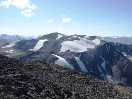
Crescent Lake visible below us, a drop of Kenai lake in the distance and Andy Simmons Mountain in the far distance.

A view into the top pf Axis glacier with Peak 5106 in the distance and the Harding Ice Sheet beyond that.

 Cooper Landing.
 On the way back down we cut off a herd of sheep, possibly the same group that grazed near our camp. We also spotted another herd several miles distant on a rib of Wrong. What a treat.


Good perspective. Photos: R.S.

Dropping back down into Dry Creek's alpine valley.


Marmot.

Looking back toward camp.

A great view of Right Mountain from across the Dry Creek alpine valley.

Back down in Cooper we took a tourist photo at the Kingfisher Roadhouse before mowing down well deserved burgers. We laughed to ourselves at how people who saw us take this photo, and ate on the Kingfisher's outside deck enjoying the same view, had no idea that the cute couple next to them had just been up there. The summit peak is the one to the far left with patch of snow underneath.
4 comments:
Nice peak bag, and great pictures!
Thanks Tim! Except for all the bugs, it was a great adventure.
Hello, Dante. I'm so glad to see someone topping out on Right Mountain. I've been wanting to do so for years, but haven't made it, despite several attempts. I have some questions for you, but I first want to correct something you stated early in the description of this trek: I know that Tony Doyle showed you or told you how to get up onto the Right Mountain massif, but Tony knew about the trail only because I took him up there earlier that same year (2010) or the year before. I actually created the trail in August 2003 and then completed the trail-building process with a buddy of mine the following month. When Tony contacted me about skiing up in the bowl on Right Mountain, I led him and two of his skiing friends up onto the ridge and then down into the bowl. After that, according to Tony, he and some other skiers rerouted parts of the trail, improving it, from what he said. However, for various reasons, the last time I climbed on Right Mountain (before today) was when I guided Tony. In the past, my goal had been to reach Axis and then traverse over to the Right Mt. summit. Each time, I was stopped by the narrow, sketchy ridge separating the 4,390-foot ridge crest from Axis itself. I long wondered about the route you and Rachel took, or about going straight up the back of the bowl behind the tarn. So I'm curious about the route you chose and why you did not go straight up the rocky back end. Today, my significant other (Yvonne) and I climbed toward the hemlock-capped first crest on the ridgeline that leads to Axis, but we were stopped by two things: (1) My old, more direct route up (from about 1,600 feet of elevation onward) seems to have overgrown and disappeared from lack of use, and (2) when we followed the new, vastly nicer continuation of the trail, it curled into the lower Dry Creek drainage and then headed into a grassy, alder-filled swale and seemed to disappear. Anyway, tell me whatever you can remember about your whole route. I'd appreciate it. Reading your blog has invigorated in me the desire to summit Right Mt. properly. Thanks for sharing. --Clark Fair (c.fair@live.com)
Clark, thanks for the info. When we did it, the vegetation just above the hemlocks was pretty dense, so, if the trail has fallen out of disuse the past 7 years, combined with the pretty spectacular veg growth this summer, I can imagine it would be close to impenetrable. One thing you might be curious to know, when we went up there in August of 2010, someone had gone up with a pack animal, and sadly, there was a lot of toilet paper strewn about in the bowl below Right and Axis.
We only went up Right. We never went over to Axis. We hiked up the grassy westerly slope of Right from the Dry Creek's tarn bowl, and then walked up Right's rolling ridge to its summit where we found a cairn. Axis would have been a pretty easy walk from there.
Post a Comment